A Field Guide to the Central Coast’s State and National Parks
A road-trip-ready guide to the wild places between Ventura and Santa Cruz, from the Channel Islands and Pinnacles to La Purusima Mission and Montaña de Oro.
California has more national parks than any other state. Stack on hundreds of state parks, beaches, land reserves and historic sites, and you start to see why the Golden State’s identity is so inherently tied to its wild places. Nowhere is that more evident than the Central Coast.
This is a region built around protecting and celebrating wide-open spaces. Think islands rising out of the Pacific, redwood canyons folded into the Santa Cruz Mountains, dunes the size of city blocks, cliffs that drop straight to surf and volcanic spires where California condors soar overhead. Two of California’s nine national parks — Channel Islands and Pinnacles — are part of the Central Coast, alongside dozens of state parks. The collective ecosystem preserves some of the most treasured landscapes in the West.
Whether you’re driving the whole coast or planning a long weekend, here’s a comprehensive guide to public lands waiting to be explored.

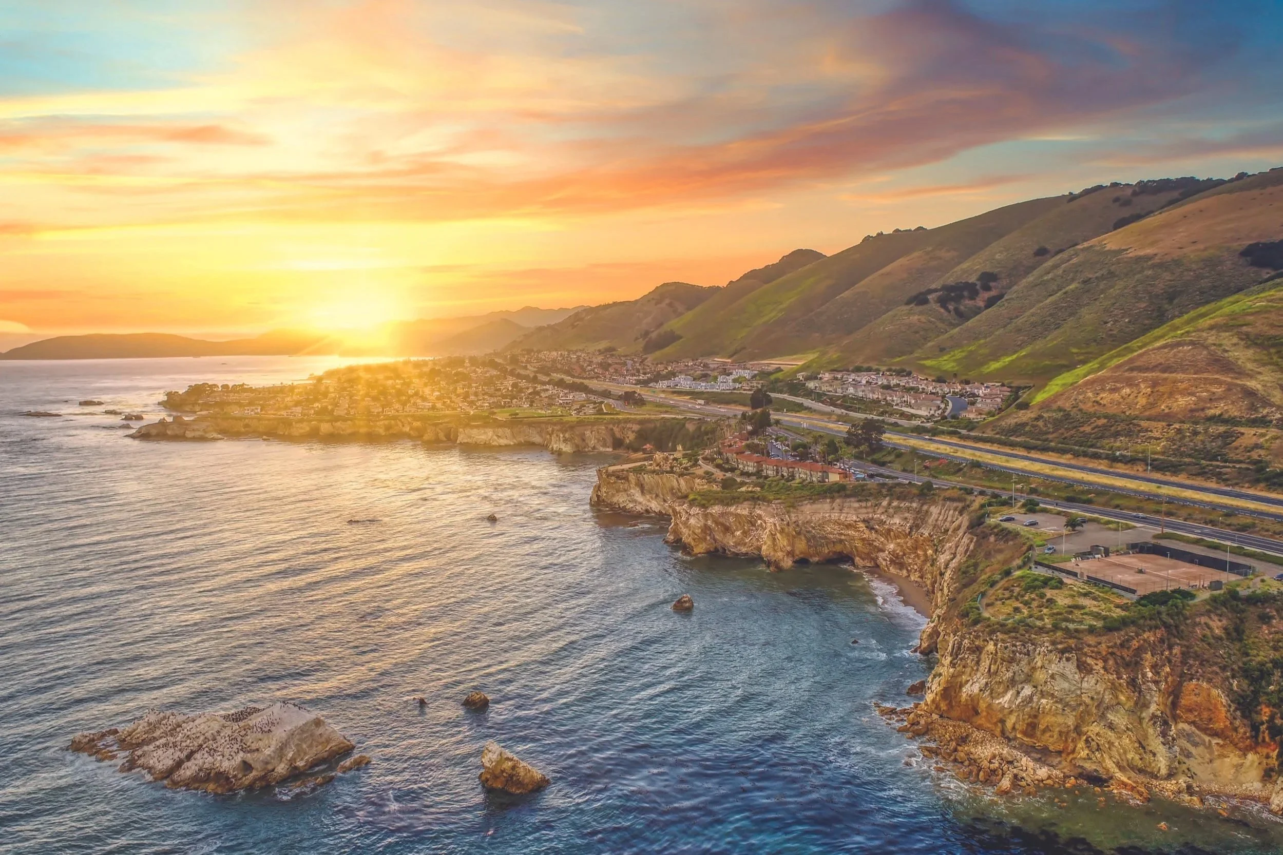
Channel Islands National Park, photo courtesy of Visit Ventura
Ventura County
Ventura County Coast is the southern gateway, where the Santa Monica Mountains tip into the Pacific and the least-visited national park in California lies a boat ride offshore with two launch points from Channel Islands Harbor in Oxnard and Ventura Harbor.
Point Mugu State Park: At the county’s southern tip, Point Mugu protects a rugged corner of the Santa Monica Mountains National Recreation Area where coastal sage scrub tumbles straight into the surf. Expect more than 70 miles of trails, five miles of shoreline and the famous Mugu Rock.
Channel Islands National Park: Often called the “North American Galápagos” for the impressive volume of species found nowhere else, the five-island park preserves an archipelago of sea caves, kelp forests, endemic island foxes and a landscape that still feels remote despite being just over an hour from shore. Island Packers ferries depart daily (conditions permitting and reservations strongly encouraged) for Santa Cruz Island and Anacapa Island day trips and overnight camping. Santa Cruz is the largest island in California and the most accessible for day trips; the signature experience is sea-kayaking into Painted Cave, one of the largest sea caves in the world.
Emma Wood State Beach: Known for old-school Pacific Coast camping just north of Ventura, train tracks sit behind the sites while the surf rolls in front. RVers and surfers love it, and the long cobblestone beach is good for poking around at low tide.

La Purisima Mission, photo courtesy of Explore Lompoc
Santa Barbara County
Santa Barbara County is known for beach towns, mission architecture and wine country. You can see the Channel Islands from Santa Barbara and take whale watching cruises and private charters to Santa Cruz Island from Santa Barbara Landing. Santa Barbara is also home to the Gaviota Coast, one of the longest undeveloped stretches of shoreline in Southern California with a trio of state beaches for campers and daytrippers.
Carpinteria State Beach: Billed as one of the world’s safest beaches for its gentle surf, Carpinteria is family-friendly and the beach is walkable from downtown and the Amtrak station. The nearby harbor seal rookery has a viewing area where you can watch seals and their pups hauled out on the sand from December through May.
El Presidio de Santa Barbara State Historic Park: Right in downtown Santa Barbara, this park preserves the site of the last Spanish military outpost built in Alta California, dating to 1782. The reconstructed adobe chapel and soldiers’ quarters make for an easy stop while exploring downtown Santa Barbara on foot.
El Capitan State Beach: Just north of Santa Barbara, El Capitan offers bluff-top campsites, tide pools, a seasonal creek down and rugged coastline. (Check for temporary closures.)
Refugio State Beach: A palm-lined cove that looks tropical, Refugio’s campsites are perched adjacent to the sand. Tide pools at the west end are worth the walk and surfers love the mellow break.
Gaviota State Park: Here, the Gaviota Coast meets the mountains with a pier and campground at the beach and backcountry trails climbing into the Santa Ynez Range. The hike to Gaviota Hot Springs is short and rewarding, and the train trestle arcing over the beach is one of the most photographed spots on Highway 101.
Chumash Painted Cave State Historic Park: This small sandstone cave in the Santa Ynez Mountains protects some of the most striking Chumash pictographs in California. The cave is gated to protect the art, but the paintings are clearly visible through the bars. It’s tiny, it’s free and the winding drive up is half the adventure.
La Purísima Mission State Historic Park: Of California's 21 missions, La Purísima is the most completely restored and the only one preserved as a state park. Founded in 1787, leveled by the 1812 earthquake and rebuilt a few miles northeast by Chumash laborers on Chumash land, it later fell into ruin before being painstakingly reconstructed by the Civilian Conservation Corps in the 1930s. The result is an entire mission complex featuring 10 original buildings, working gardens, a three-mile aqueduct system and livestock still grazing the corrals. The 2,000-acre park and National Historic Landmark features 25 miles of hiking and equestrian trails and is located on the outskirts of Lompoc.
Pismo Beach coastline, photo courtesy of Visit Pismo Beach
San Luis Obispo County (SLO CAL)
This is where the Central Coast opens up. The population thins, Highway 1 starts to feel like a proper scenic drive and the parks get bigger and wilder — Morro Rock, elephant seals, monarch butterflies and Hearst Castle dot an epic stretch of coastline.
Oceano Dunes State Vehicular Recreation Area: This is the only place in California where vehicles have historically been allowed to drive on the beach. Even on foot, the dunes themselves — some towering 500 feet — are worth the trip, whether exploring by ATV or sliding down on a sandboard. (Note: As of April 2026, a federal court ruling has temporarily suspended off-highway vehicle use south of Arroyo Grande Creek to protect the endangered western snowy plover. Day use and street-legal vehicle access north of the creek remains open, with a 1,000-vehicle daily cap. Camping and reopening timelines depend on the completion of a Habitat Conservation Plan — check current conditions before you go.)
Pismo State Beach & Monarch Butterfly Grove: From late October through February, monarch butterflies gather in the eucalyptus and Monterey cypress trees at the Pismo Monarch Grove, one of the West Coast’s most beloved overwintering sites. The rest of the park covers miles of classic Central Coast beach, with camping at North Beach and Oceano campgrounds.
Montaña de Oro State Park: The “Mountain of Gold” sprawls across more than 8,000 acres of bluffs, beaches and coastal hills south of Morro Bay. The Bluff Trail is a popular short coastal walk, while Valencia Peak climbs to a summit view that takes in the whole of Estero Bay.
Morro Bay State Park: Built around the estuary at the foot of Morro Rock, this park offers a heron rookery, kayaking through the bay and the excellent Morro Bay Museum of Natural History perched on a rocky outcrop. The campground sits under eucalyptus trees that sometimes host monarchs in winter.
Morro Strand State Beach: A long, flat stretch of sand running north from Morro Rock toward Cayucos, it’s a classic beachcombing, kite-flying walk-for-miles kind of beach.
Los Osos Oaks State Reserve: This small reserve protects a grove of ancient, twisted coast live oaks — some more than 800 years old — growing out of stabilized sand dunes. Short loop trails wind through a forest that feels almost otherworldly.
Cayucos State Beach: A small-town beach anchored by an 1870s pier, Cayucos is popular with anglers, the beach is a kite flyer’s dream when the breeze picks up and the protected cove is inviting for summer swimming.
Estero Bluffs State Park: A quieter cousin to Montaña de Oro, Estero Bluffs protects a four-mile strip of bluff-top trails just north of Cayucos. Harbor seals pup on the rocks offshore in spring. The whole park has a raw, windswept feel.
Hearst San Simeon State Park & Hearst Castle State Historic Monument: Hearst San Simeon protects miles of coastal bluffs with boardwalks over wetlands and one of the oldest state parks in California. Up the hill, Hearst Castle — the former estate of William Randolph Hearst — is a state historic monument and a tour-only experience, with extravagant rooms, gardens and the iconic Neptune Pool. Just up the road, the Piedras Blancas elephant seal rookery is a free, year-round wildlife show.
Harmony Headlands State Park: An undeveloped slice of coast between Cayucos and Cambria, Harmony Headlands feels like stepping back in time to an older version of California. A flat, easy trail crosses grasslands to reach unbroken coastal bluffs, and you’ll often have the place to yourself.

Pinnacles National Park, photo courtesy of See Monterey
The Monterey Bay Region
This is where the Central Coast’s biggest trees tower in the Santa Cruz Mountains and the most famous stretch of Highway 1 winds through Big Sur to Carmel-by-the-Sea. The Monterey Bay region — encompassing Monterey, Santa Cruz and San Benito counties — is also home to the volcanic spires of Pinnacles National Park.
Pfeiffer Big Sur State Park: In the heart of Big Sur, this redwood-filled valley along the Big Sur River features a family-friendly campground with the classic Big Sur Lodge at its center. The short hike to Pfeiffer Falls is a good introduction, while the longer climb up Mount Manuel offers a more intense workout.
Julia Pfeiffer Burns State Park: Home to McWay Falls, this park delivers one of the most photographed views on the entire California coast. The overlook is a short, easy walk from the parking lot, making it one of the highest reward-to-effort ratios in the state park system. (Check website for temporary closures and trail maintenance.)
Andrew Molera State Park: The largest state park in Big Sur and less developed than its neighbors, here trails wind through meadows and along the Big Sur River to a wild, driftwood-strewn beach. A good place to escape the Highway 1 crowds and a frequent spot for condor sightings.
Garrapata State Park: Just south of Carmel, Garrapata offers bluff-top trails with sweeping coastal views and, in early spring, the famous Calla Lily Valley, where the white flowers bloom in a creek canyon just steps from the ocean. Parking is along Highway 1, so go early.
Point Lobos State Natural Reserve: Often called the “crown jewel” of the California State Park system, Point Lobos is a compact masterpiece — sea cliffs, cypress groves, hidden coves and kelp-fringed tide pools. The loop trails are short and flat, but you could spend a whole day here and still not see it all.
Asilomar State Beach: A mile of rocky coastline in Pacific Grove, Asilomar pairs tide pools and surf breaks with a boardwalk through restored dunes. It presents a quiet alternative to some of the more famous stretches of the Monterey Peninsula.
Carmel River State Beach: Where the Carmel River meets the sea, discover a protected lagoon excellent for bird-watching, a white-sand beach beautiful for walking (but unsafe for swimming with strong rip currents) and views south toward Point Lobos.
Fort Ord Dunes State Park: Built on the former Army base at Fort Ord, this park protects four miles of coastline and rolling dune habitat that was off-limits to the public for generations. Paved and sandy trails make it accessible, and the beach is often empty.
Fremont Peak State Park: Straddling the Monterey/San Benito county line in the Gabilan Range, Fremont Peak offers sweeping views over the Salinas Valley and Monterey Bay from its 3,169-foot summit. It’s also home to the Fremont Peak Observatory, which hosts public stargazing nights on weekends — the dark skies here are some of the best within easy reach of the Bay Area.
Big Basin Redwoods State Park: California’s oldest state park established in 1902, Big Basin was reshaped by the 2020 CZU Lightning Complex fires, which burned roughly 97% of its acreage and destroyed nearly all historic infrastructure. The park is reopening in phases through a reservation-based day-use system, with around 20 miles of trails and fire roads now accessible. Most of the old-growth redwoods survived, and the forest is in active recovery — a visit here is both a hike and a lesson in how these ancient ecosystems heal themselves.
Henry Cowell Redwoods State Park: Just outside the town of Felton, Henry Cowell preserves a 40-acre grove of old-growth coast redwoods on a flat, wheelchair-accessible loop — the easiest way to see truly ancient trees in the Santa Cruz Mountains. The park also includes the separate Fall Creek Unit, a fern-lined canyon with year-round creeks, old lime kiln ruins and 20-plus miles of quieter trails.
The Forest of Nisene Marks State Park: Tucked above Aptos, Nisene Marks is home to 10,000 acres of second-growth redwoods reclaiming land that was clear-cut a century ago. The trails are shady, lightly trafficked and excellent for trail running or long day hikes.
Wilder Ranch State Park: Just north of Santa Cruz, Wilder Ranch combines a preserved 19th-century dairy ranch with miles of coastal bluff trails and mountain biking routes that climb into the redwoods. A rare park where you can tour historic buildings and ride singletrack in the same visit.
Natural Bridges State Beach: Named for the sea arch offshore, Natural Bridges is small but mighty with excellent tide pools and one of the strongest monarch butterfly overwintering sites on the Central Coast (October through early February). The Monarch Trail is short and stroller-friendly.
Castle Rock State Park: High along the Santa Cruz Mountains ridgeline, Castle Rock protects an unusual landscape of sandstone formations, where wind- and water-sculpted rocks pocked with curious hollows are set in a forest of redwood, Douglas-fir and madrone. A popular spot for bouldering and the western trailhead for the Skyline-to-the-Sea Trail.
Seacliff, New Brighton, Sunset & Manresa State Beaches: This string of state beaches along Monterey Bay is the classic summer-camping stretch offering bluff-top sites, easy access to the sand and gentle surf. Seacliff is famous for the “Cement Ship,” the S.S. Palo Alto, a concrete tanker from WWI that was grounded as a pier and gradually broken up by storms.
Henry W. Coe State Park: The second-largest state park in California sprawls across 87,000 acres of remote, rugged backcountry east of Morgan Hill. It is serious hiking country, with oak savannas, steep ridges and backcountry lakes that reward overnight trips. In spring, the wildflowers are particularly spectacular.
Pinnacles National Park: The region’s second national park and the newest designated in California, Pinnacles is genuinely unlike anywhere else in the state. The landscape of volcanic spires was created when a piece of an ancient volcano, originally near present-day Lancaster, was split and carried nearly 200 miles north by movement along the San Andreas Fault. The park is one of the best places in the world to see the endangered California condor as a key release site for the species recovery program, where the massive birds (with wingspans of 9.5 feet) ride thermals above the High Peaks most mornings and evenings. (Note that the east and west entrances don’t connect by road, so pick a side to explore.)
Hollister Hills State Vehicular Recreation Area: Just south of Hollister, this off-road riding area boasts more than 6,800 acres of hills, trails and practice areas for motorcycles, ATVs and 4x4s. If that’s your sport, it’s one of the best dedicated OHV parks in California.
San Juan Bautista State Historic Park: Anchoring the plaza across from Mission San Juan Bautista, this park preserves a 19th-century stagecoach stop, a historic hotel, a blacksmith shop and a Spanish-era adobe. It’s small, walkable and features a Hitchcock landmark: the mission next door is the setting of the final scene in Vertigo.
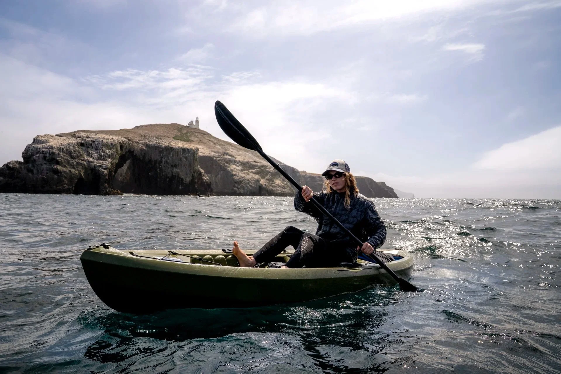
Anacapa Island, photo courtesy of Visit Oxnard
Plan Your Visit
Passes: A California State Parks Day Use Annual Pass (the “Poppy Pass”) covers day-use parking at most state parks; check the latest rate at parks.ca.gov. For national parks, the America the Beautiful Pass (prices start at $80/year) covers entrance fees at Channel Islands (entrance is free, but boat-concessionaire fees apply) and Pinnacles. State park camping is booked through ReserveCalifornia.com; national park campgrounds go through Recreation.gov.
Seasons: Winter brings monarch butterflies to Pismo and Natural Bridges (roughly November–February) and elephant seals to Año Nuevo and San Simeon (December–March). Spring wildflowers peak at Garrapata, Henry Coe and Pinnacles (March–April). Summer is the high season for coastal camping — book early. Fall is arguably the best all-around with fewer crowds, warmer waters and clear skies.
A few practical notes: Big Sur weather and road conditions can change fast — check Caltrans before driving Highway 1. Channel Islands trips require booking a boat with Island Packers well in advance. Pinnacles’ summer temperatures routinely top 100°F; visit earlier in the day for cooler temperatures.